

Projects
See the latest update on projects and initiatives recommended in the plan.
The Region
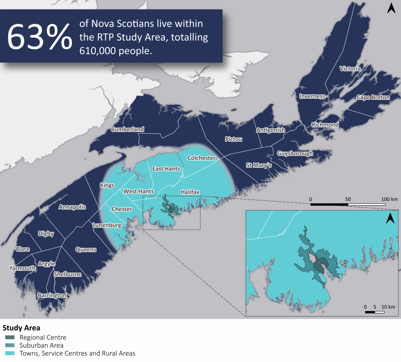
The RTP study area is centred on Halifax and includes communities within a roughly one-hour drive, which is defined as the Region. It includes five First Nations communities, 15 municipalities, and 19 historic African Nova Scotian communities.
The Region includes 14 municipalities outside of HRM:
- Municipality of the County of Colchester
- Municipality of the County of Kings
- Municipality of the District of Chester
- Municipality of the District of Lunenburg
- Municipality of East Hants
- Town of Berwick
- Town of Bridgewater
- Town of Kentville
- Town of Lunenburg
- Town of Mahone Bay
- Town of Stewiacke
- Town of Truro
- Town of Wolfville
- West Hants Regional Municipality
First Nations:
- Annapolis Valley
- Glooscap
- Millbrook
- Sipekne’katik
- Wasoqopa’q
Historic African Nova Scotian communities:
- Africville
- Aldershot
- Beechville
- Cambridge
- Cherry Brook
- Cobequid Road
- Dartmouth
- East Preston
- Five Mile Plains
- Gibson Woods
- Halifax
- Kentville
- Lake Loon
- Lucasville
- Maroon Hill
- North Preston
- Old Guysborough Road
(Goff’s) - Truro
- Upper Hammonds Plains
Vision
Nova Scotians have a safe, efficient, equitable, and resilient regional transportation system. Our people and communities are healthy, connected, and prosperous, powering a strong regional economy.
Principles
All aspects of the planning process are guided by the below.
Accessibility
Provides access to affordable, welcoming, inclusive, and efficient transportation essential for communities to thrive. The design of the system aligns with the province’s goals for an accessible Nova Scotia by 2030.
Collaboration
Integrates a diverse range of ideas to advance regional transportation solutions that address challenges and maximize opportunities.
Equity
Addresses transportation needs for underrepresented and underserved communities so all Nova Scotians can travel easily throughout the region.
Resiliency
Prioritizes solutions that enhance the ability to recover from service disruptions and reduces the transportation system’s vulnerability to climate impacts.
Sustainability
Prioritizes transportation solutions and coordinated land use that reduce greenhouse gas emissions to meet the province’s net-zero target and protects environmental, agricultural, and cultural assets.
Well-being
Better connections for Nova Scotians to one another and the goods, places, and services they need to help build prosperous, safe, and healthy communities.
How the plan was developed
Link Nova Scotia led a collaborative effort to develop the RTP. The planning process included:
- Analysis and modelling using scenario planning and a state-of-the-art travel demand model.
- Building on existing work by Core Partners, municipalities, and Provincial departments.
- Engagement with focus groups, the public, and community-led outreach.
Goals
The collaborative planning process resulted in five goals to transform the Region’s transportation system. All actions in the plan are organized under these goals:


A Strategic Approach
The RTP represents a strategic approach to regional transportation planning based on:
- Collaboration led by Link Nova Scotia and its Core Partners
- Tackling congestion by investing in strategic road projects and more transportation options for Nova Scotians, such as rapid transit.
- Coordination between transportation and land use planning to ensure the transportation system can best serve the Region.
- Capitalizing on technological developments in the transportation sector which can improve safety, efficiency, reliability, and future proof the system.
Making the Plan Happen
The RTP sets a course of action to create a transportation system that addresses the needs of today and supports additional growth in the future. The Province, through Link Nova Scotia, will be at the forefront of this transformation, working with Core Partners, municipalities, and the public.
Implementation
Link Nova Scotia is already planning for the implementation of the RTP. It will be a complex undertaking requiring commitment from the Province and collaboration from all Core Partners, municipalities, and community. The work so far includes:
- A set of priority recommendations to guide next steps.
- Identification of funding sources for major projects, including the Canada Public Transit Fund for rapid transit which supports increased housing supply.
- A review to consider suitable governance and management models to provide clarity of roles and responsibilities in the Region and streamline delivery.
Evaluation
The RTP includes mechanisms for Link Nova Scotia to provide updates on progress made.
- Implementation progress will be reported on regularly, with each action tracked.
- Key performance indicators have been developed to monitor the plan’s impact and will be reported on every five years.
- A full plan review will be conducted every 10 years and the plan updated to account for demographic, technological, economic, and societal changes.